NORKA
  • Home
    • About
    • Reviews
    • Contact
  • People
    • Founders
    • Personal Histories
    • Notable Norkans
    • Stories
    • Photo Identification
    • Photo Gallery
  • Community
    • Village Life
    • Entertainment
    • Agriculture
    • Climate
    • Homesites
    • Geographical Description
    • Government
    • Social Structure
    • Health
    • Education
    • A Land of Ethnic Diversity
    • Cottage Industries >
      • Sarpinka
      • Mills
    • Language
    • Population
    • Military Service
    • Crime and Punishment
  • History
    • Timeline
    • Origins of the Colonists
    • Catherine's Manifesto 1763
    • Why go to Russia?
    • Recruitment 1766
    • Planning 1764-1766
    • Marriages Prior To Emigration 1766
    • Voyage to Russia 1766 >
      • Ship Transport 1766
    • Journey 1766-1767
    • Founding of Norka 1767
    • Early Years 1767-1769
    • Norka 1769
    • Pallas Report 1773
    • Pugachev Raid 1774
    • Norka 1775
    • Norka 1798
    • Norka 1811
    • Napoleons Soldiers
    • Norka 1834
    • Daughter Colonies 1850s >
      • Neu-Norka
      • Oberdorf
      • Brunnental
      • Rosenfeld (am Jeruslan)
      • Neu Hussenbach (Gaschon)
    • Privileges Lost 1871-1874
    • Immigration 1875-1924 >
      • To the United States >
        • Colorado
        • Ft Collins Colorado
        • Globeville Colorado
        • Mason City, Iowa
        • Culbertson, Nebraska
        • Lincoln, Nebraska
        • Sutton, Nebraska
        • Burlington, Oklahoma
        • Weatherford, Oklahoma
        • Canby, Oregon
        • Portland, Oregon
      • To Canada >
        • Duffield, Alberta
        • Ponoka, Alberta
        • Spruce Grove, Alberta
        • Stony Plain, Alberta
        • Vegreville, Alberta
        • Arcola, Saskatchewan
      • To Germany
      • To South America
    • Famine 1891-1892
    • Norka 1898
    • War & Turnoil 1904-1906
    • World War 1914-1918
    • Revolution & War 1917-1922
    • Soviet Rule 1918-1941
    • Famine 1921-1924
    • Famine 1932-1933
    • The Great Terror 1936-1938
    • Deportation 1941
    • Repression 1941-1956
    • Cultural Loss 1957-2006
    • A Culture in Peril
    • Recent Times
  • Traditions
    • Food and Drink
    • Clothing
    • Holidays >
      • New Year
      • Fastnacht
      • Lent
      • Easter
      • Ascension Day
      • Pentecost
      • Founder's Day
      • Harvest Festival
      • Jahrmarkt
      • Christmas
      • Anniversaries & Birthdays
    • Crafts
    • Games
    • Folk Medicine
    • Superstitions
    • Nicknames
    • Folk Music
    • Church Music
    • Prayers
    • Baptism
    • Confirmation
    • Communion
    • Weddings
    • Funerals and Burials
  • Religion
    • Planning and History >
      • Norka Reformed Church 1767-1864
      • 1909 Norka Parish Report
    • Pastors >
      • Johann Heinrich Fuchs
      • Johann Georg Herwig
      • Johannes Baptista Cattaneo
      • Lukas Cattaneo
      • Emanuel Grunauer
      • Friedrich Börner
      • Christian Gottlieb Hegele
      • Christoph H Bonwetsch
      • Gottlieb N Bonwetsch
      • Wilhelm Staerkel
      • Woldemar Sibbul
      • David Weigum
      • Friedrich Alexander Wacker
      • Emil Pfeiffer
    • Church Practices >
      • Parochial Certificates
    • Church Buildings
    • Church Organs
    • Bell Tower
    • Brethren Movement
  • Resources
    • Family Research
    • Research Resources >
      • Arrival Records 1766
      • Descendant Charts
      • German EWZ Records
      • Soviet Gulag Records
    • Maps
    • Glossary
    • Bibliography
    • Periodicals >
      • Die Welt-Post Letters
    • Related Links
Resources > Maps

Maps

The colony of Norka (Russian = Норка) was documented on a number of maps beginning in the 1760s. The village is known as Nekrasovo today.
Current map of Norka (now Nekrasovo, Saratovskaya oblast, Russia) from Google Maps.


Current map of Norka (now Nekrasovo, Saratovskaya oblast, Russia) from the Russian Yandex Maps. This maps shows current street and geographic names.

A searchable Google Map showing all of the Volga German colonies.

A searchable Google Map showing German Settlements by the year founded.

Volga River Map 1662
Map of the Volga River drawn in 1662 showing frontier town of Saratov and the surround region. This map represents the Volga German settlement area approximately 100 years before the colonists arrived.

Picture
Map showing the area around the frontier town of Saratov in 1745, prior to the settlement of the Volga Germans beginning in 1764. No settlements are shown in the area where Norka was established in August 1767. Source: "Delineatio Fluvii Volgae a Samara usque ad Tsaricin" from the David Rumsey Historical Map Collection.

Volga River from Samara to Tsaritsyn. Map of 1745
"Volga River from Samara to Tsaritsyn. Map of 1745." Source: http://www.etomesto.ru/map-saratov_1745/

Map published in 1765 showing area of Volga German settlements
A map published in 1765 titled "A most accurate map of those parts of the Astracan government upon the river Wolga where in the new colonies are settled, taken from original drawings & observations made in a late survey of those countries". Source: https://gallica.bnf.fr/ark:/12148/btv1b53039154g

Map of the Volga German colonies produced in 1768.
The map produced by Johann Reis titled "Deutsche Kolonie im Wolgagebiet 1768." Lithographie im Russichen Militaerhistorischen Archiv, Moskau. This map can be purchased from AHSGR (Map #62).

Kolonie Norka
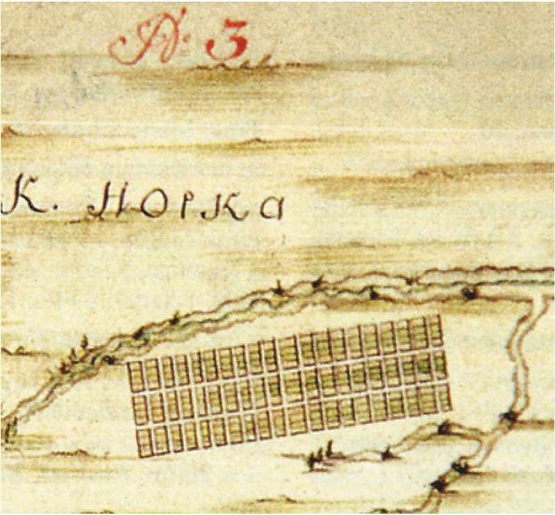
A map of the colony of Norka from the book "Einwanderung in das Wolgagebeit 1764-1767, Band 3" by Igor Pleve. The image is part of a larger lithograph from the Russian Military History Archive in Moscow and is dated 1768. See the full map above.

Overlay of 1768 map of Norka with Google Earth image
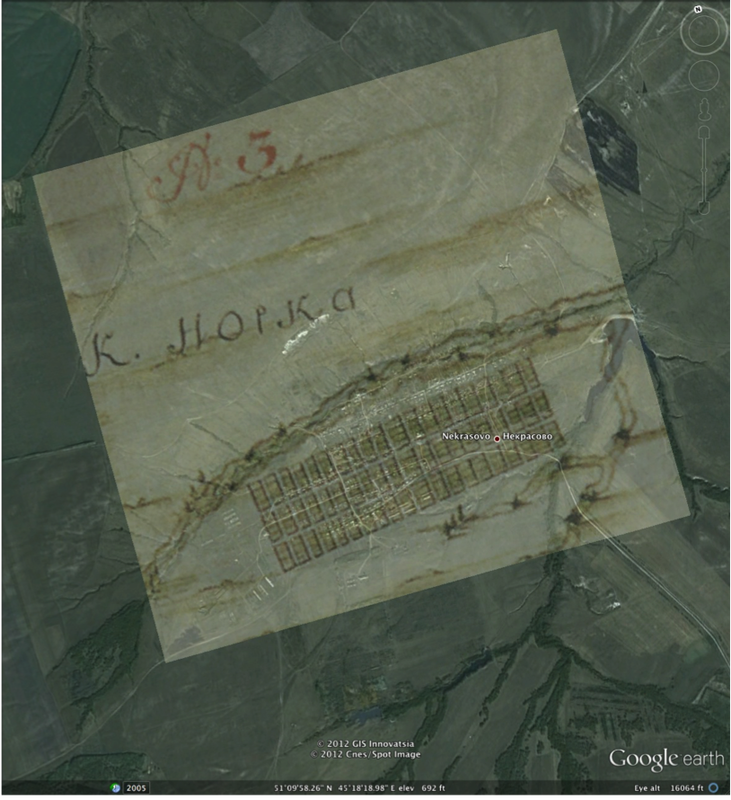
Overlay of a 1767 map of Norka on a 2012 Google Earth satellite image of Norka.

Volga German colonies map 1773
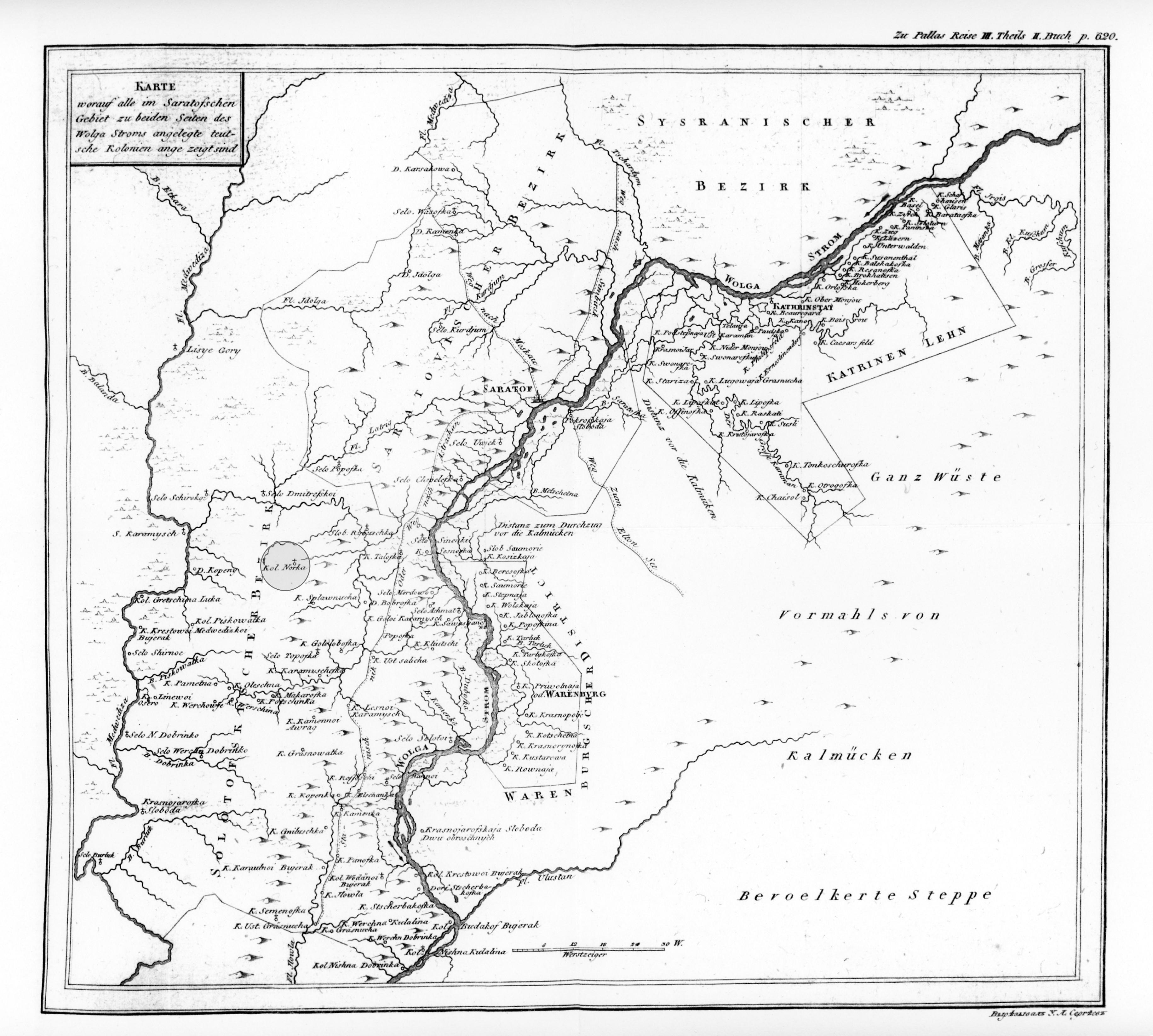
1773 map of the Volga German colonies from the expedition of Peter Simon Pallas, a German botanist and zoologist. From the book titled "Reise durch vershiedene Provinzen des Russichen Reichs; 3 Theil, 2 Buch." The colony of Norka is circled and shaded in gray.

Volga German colonies map 1773
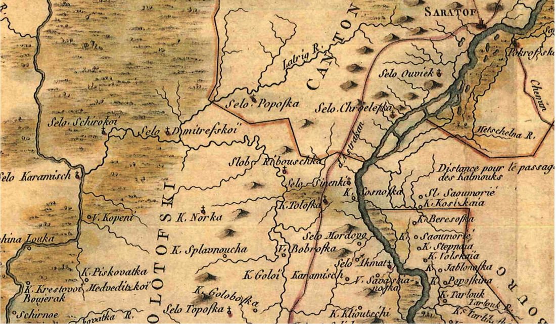
Early map of the Volga German settlements. The colony of Norka (K. Norka) is shown center left. This map appears to be a version of the Pallas map from 1773 shown above.

Picture
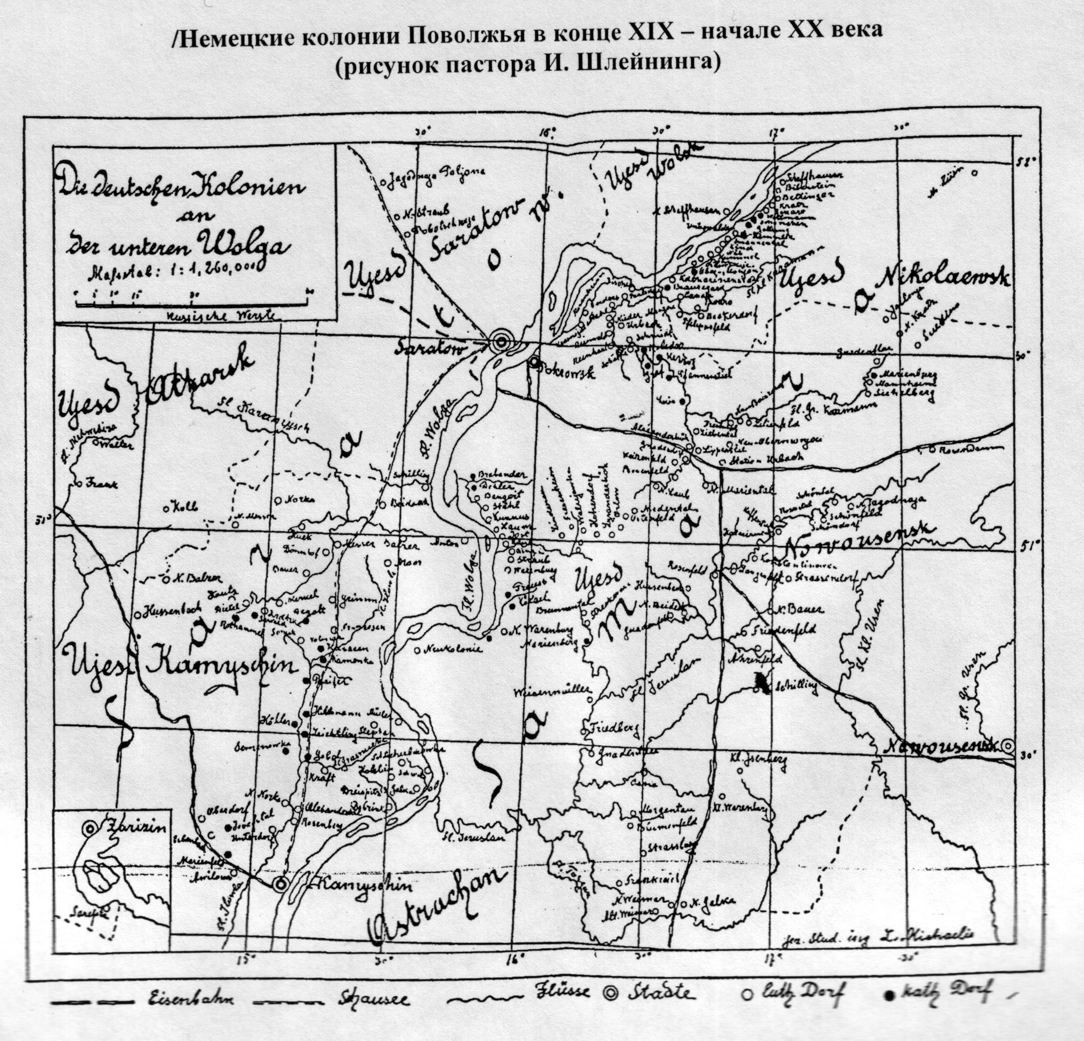
Hand drawn map of the Volga German colonies.

Map of Saratov Province in 1792
Saratov Province in 1792 from the website: http://genze.webstolica.ru/mesta-zhitelstva-genze/povolzhe/saratovskaja-gubernija

Picture
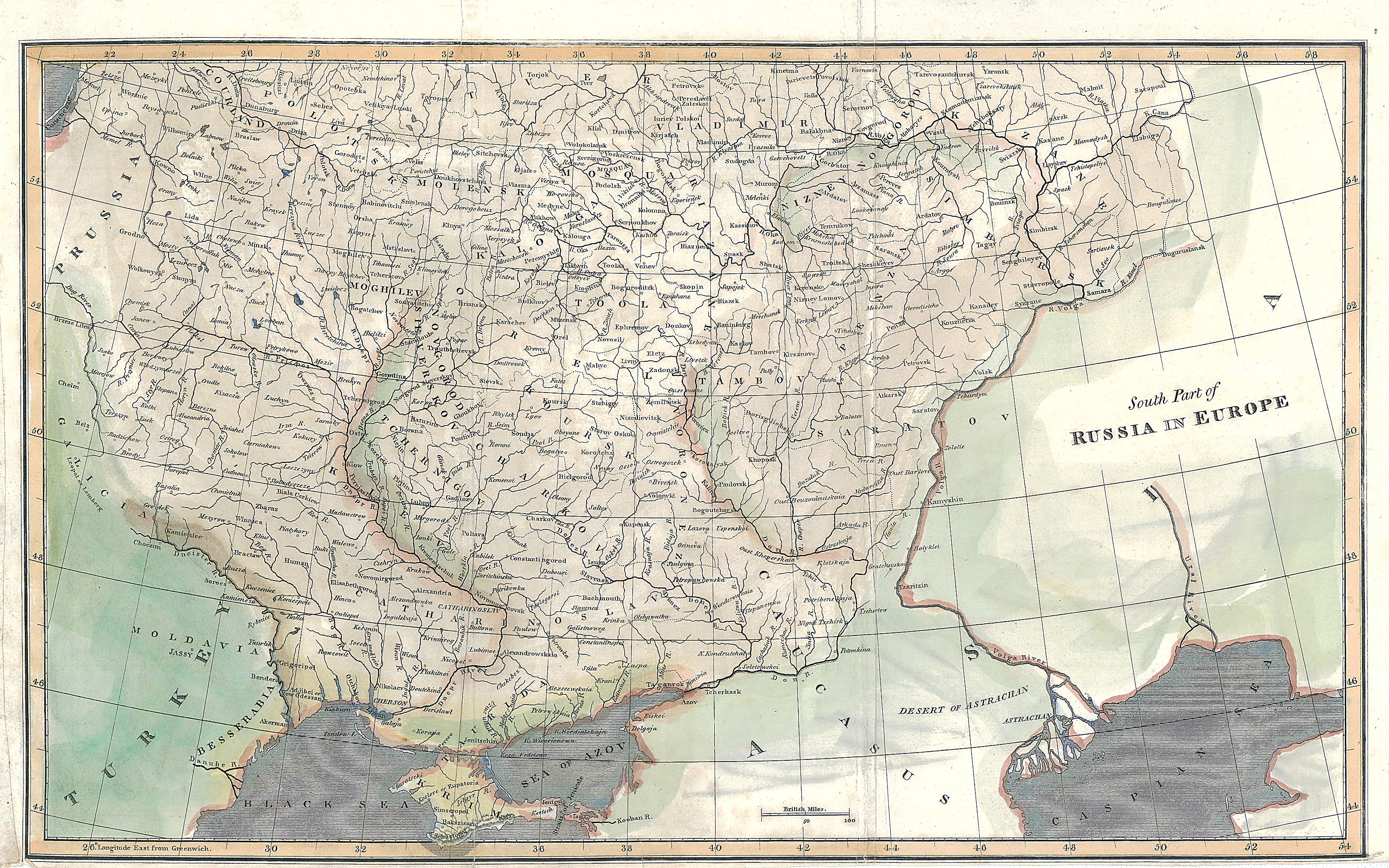
Map of Southern Russia in 1812. Norka is located in the area near the second "A" in SARATOV. The Volga German colonies were on the eastern frontier of Russia at this time.

Saratov Province 1823
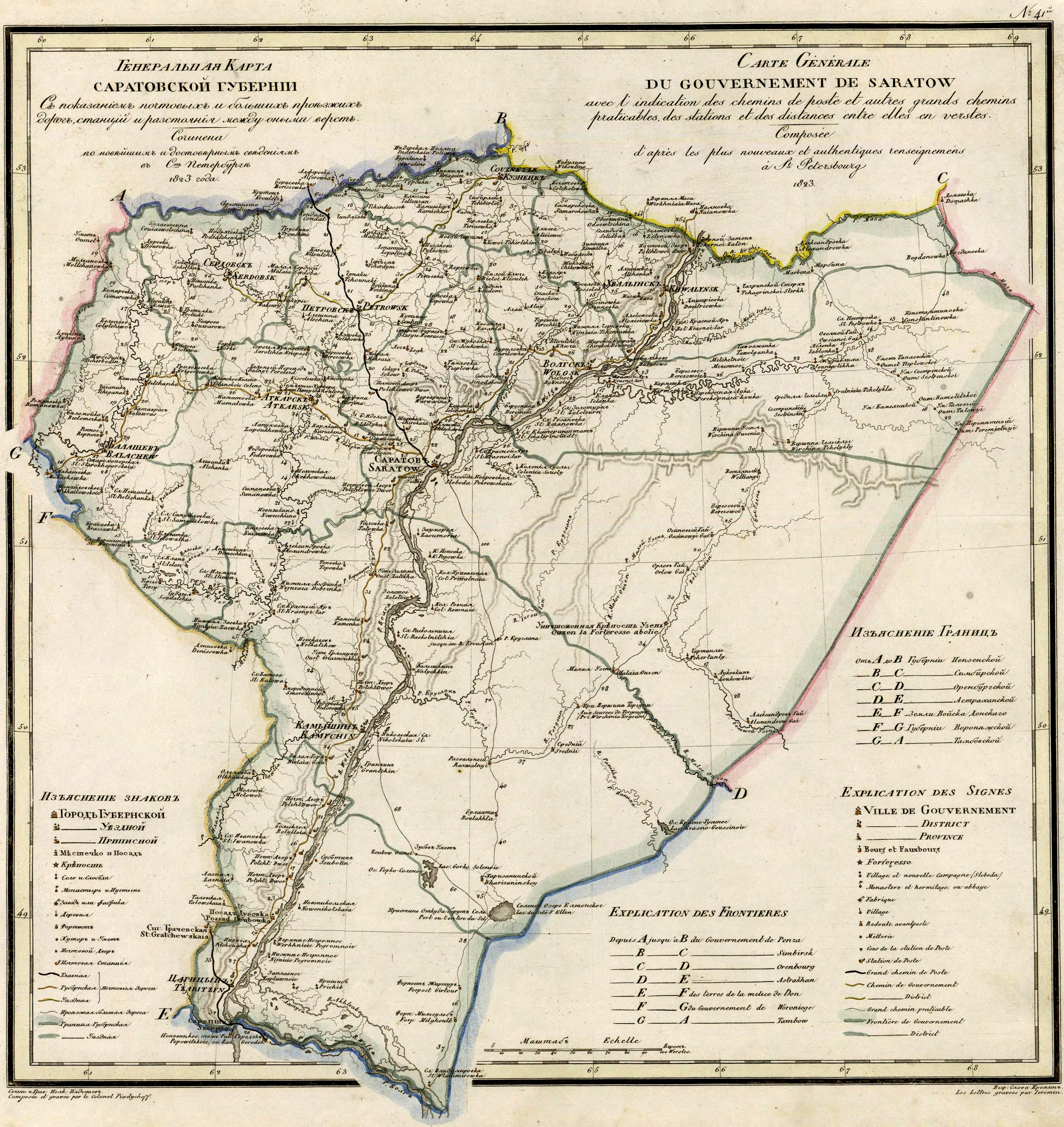
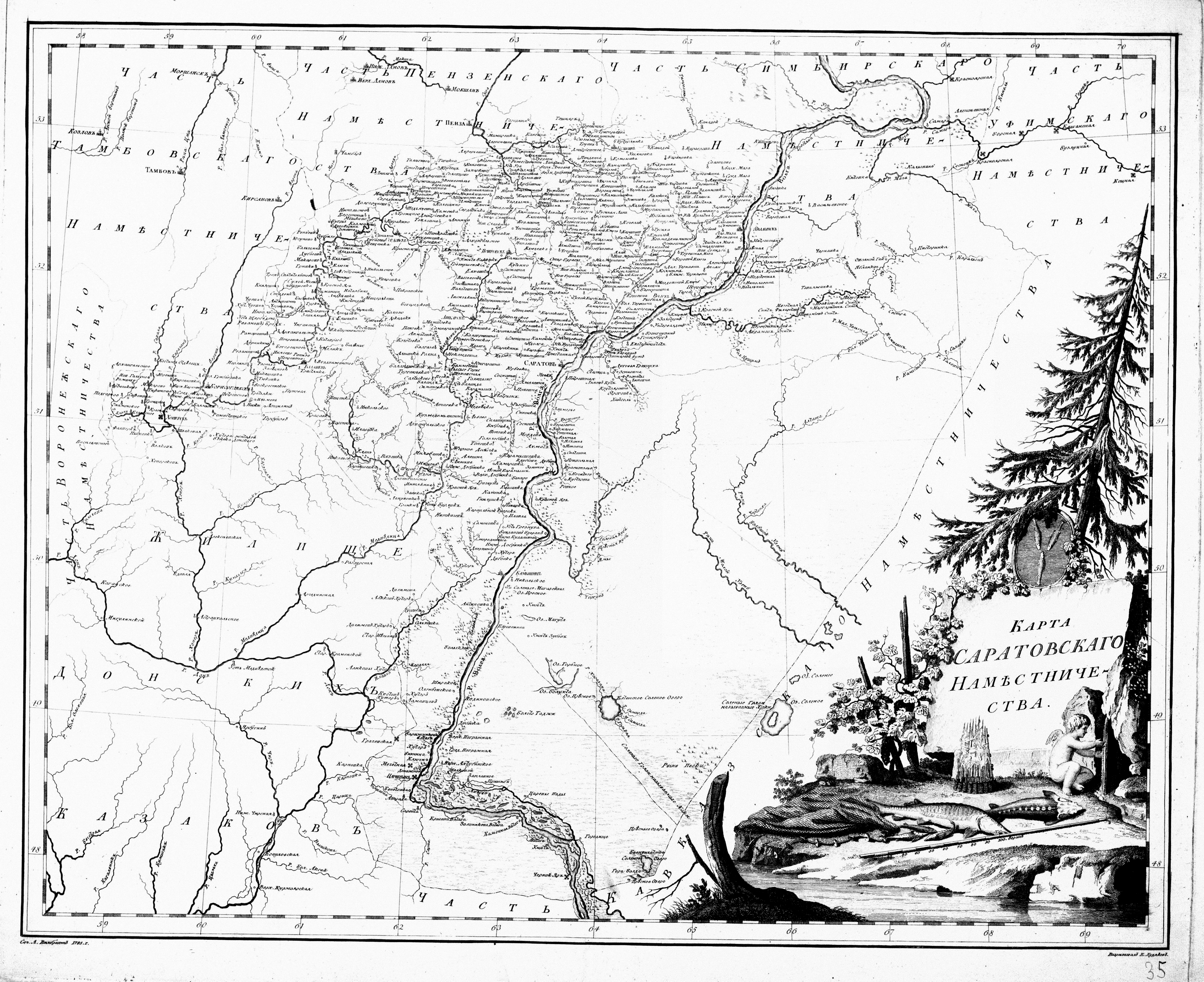
Map of Saratov Province 1823

Karte des europäischen Russlands
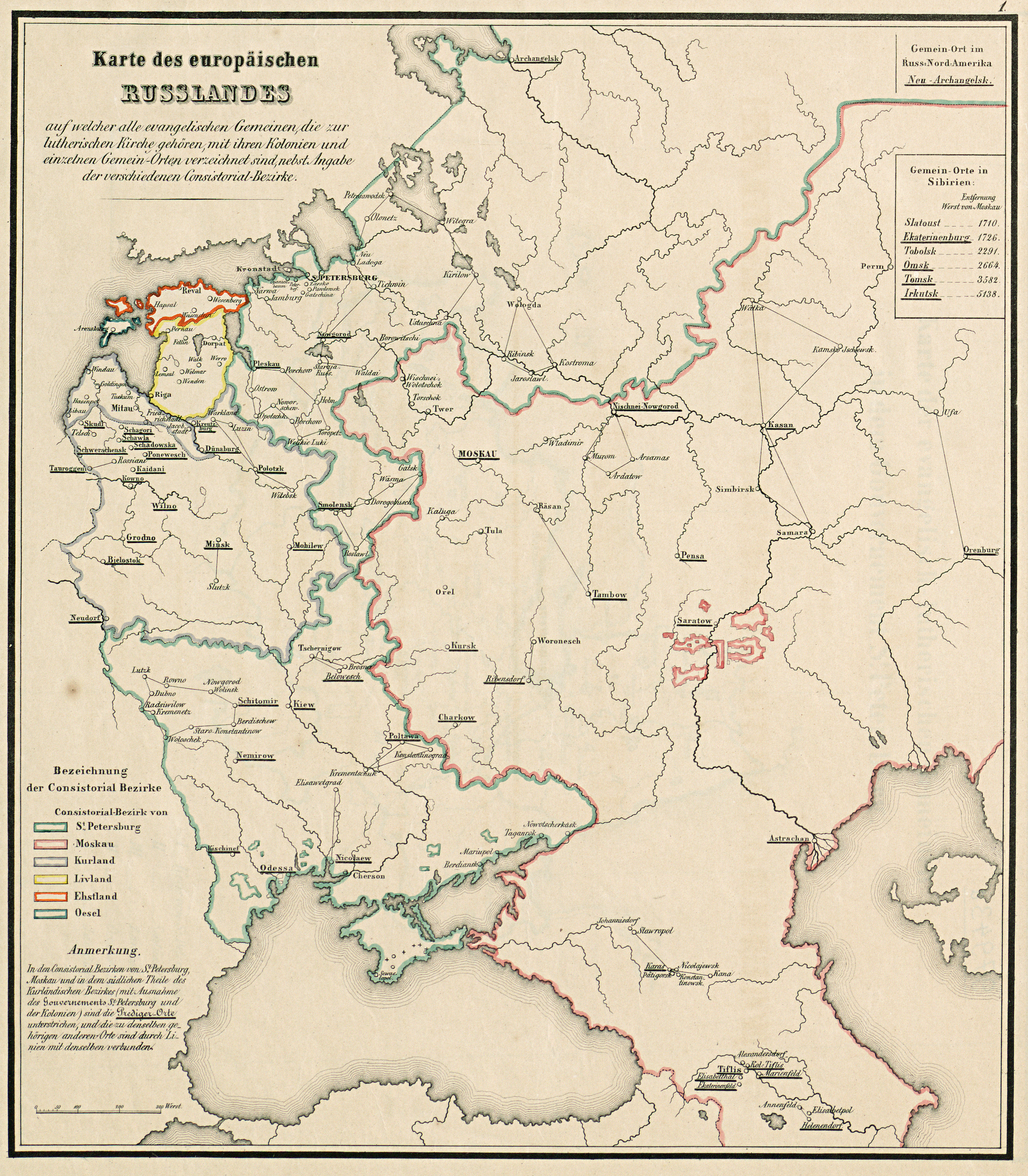
Map titled "Karte des europäischen Russlands" dated 7 March 1855. Used with permission of the Basel Mission Archives Reference (BMA ATL-31.011.0010). The map shows the various Lutheran consistories, including Saratov and Moscow.

Picture
Map of the Saratov (German = Saratow) region by Adolf Steiler in 1882. The pink area shows the German settlement area at this time. Norka is shown as one of the larger settlements in the region.

Map of Saratov Province from the Saratov Calendar 1888
Map of the Saratov region from "Саратовский календарь на 1889" (Saratov Calendar 1889 - page 83). The colony of Norka (Hopka) is shown southwest of Saratov.
Link to the complete version of "Саратовский календарь на 1889" (Saratov Calendar 1889)

Picture
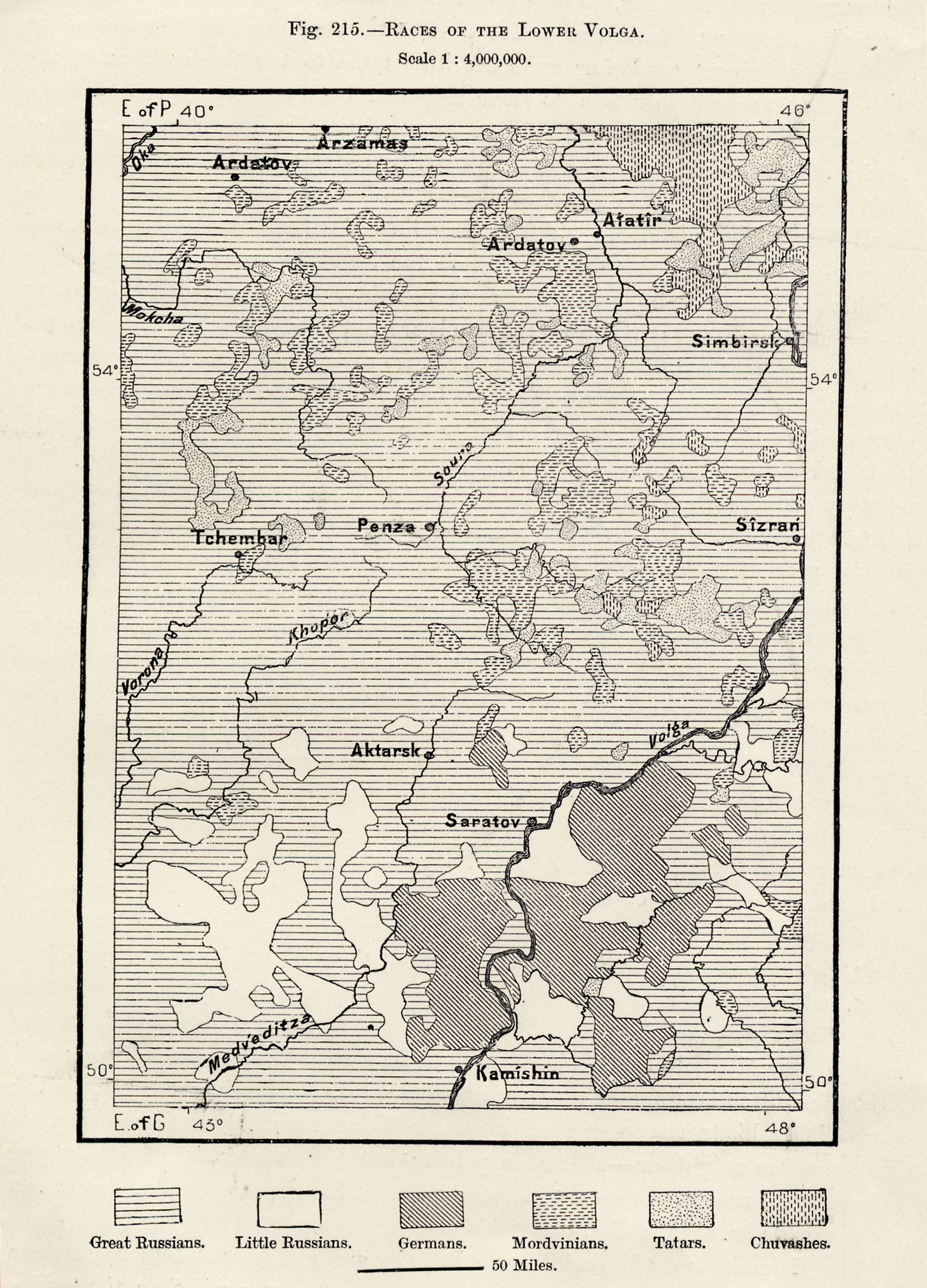
A map depicting the "Races of the Lower Volga". This map is apparently from a book titled "Russia in Europe" and was published around 1890. Source: Steve Schreiber.

Map of German colonies in the Slavic East
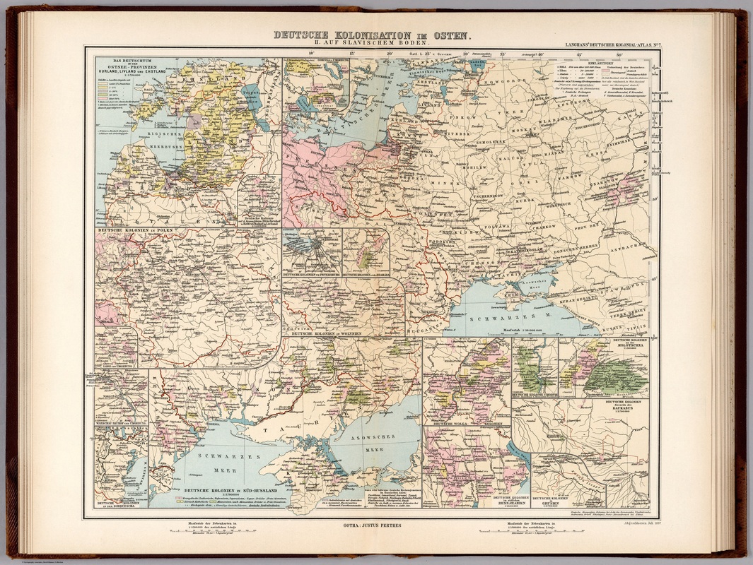
From "Deutsche Colonial-Atlas." Map titled "Deutsche Colonization im Osten. II. Aug Slavischem Boden". (German colonization in the Slavic east) - 1897. From the David Rumsey Map Collection. The colony of Norka is shown near Saratov (Saratov), Russia.

1878 Ethnographic Map of Russia
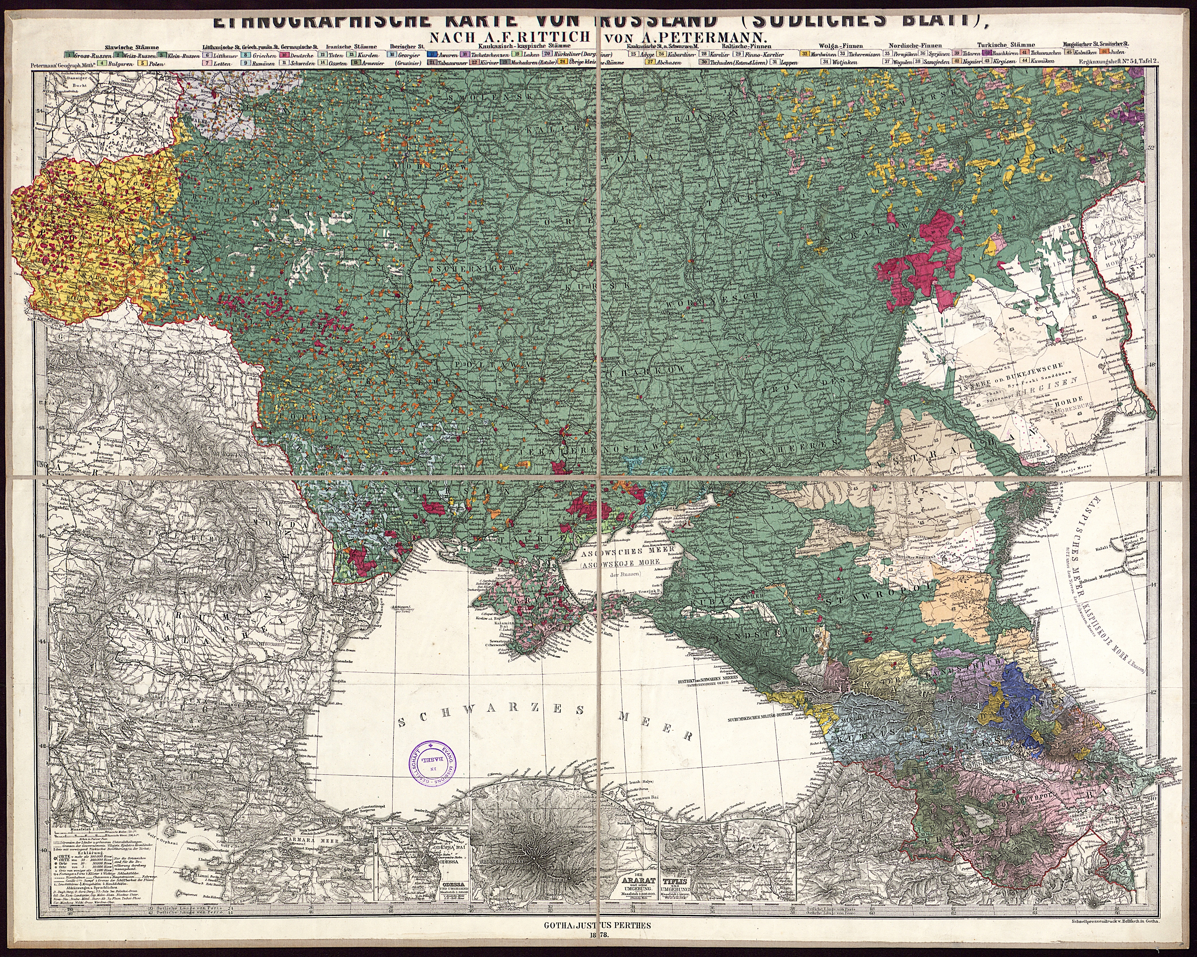
1878 map titled "Ethnographic map of Russia (southern sheet)". Used with permission of the Basel Archive Ref. number: BKARVAR-31.011. German settlements are shown in red. The Volga settlements are located in the upper right quadrant and Norka is shown. Click map for a larger image.

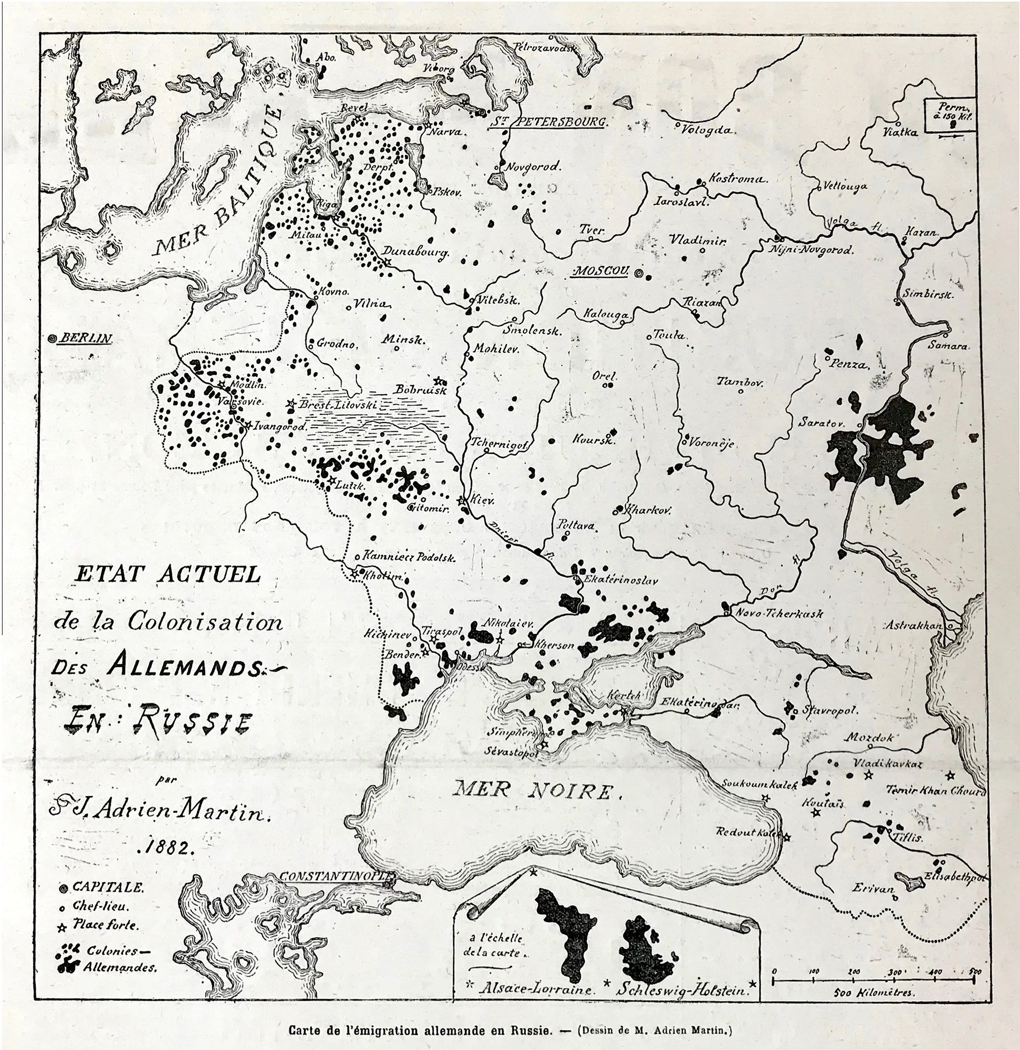
A French map from 1882 showing the German colonies in Russia. Source unknown.

Picture
Ethnic Map of the Volga Region (1901). German settlements are shown in blue. Source: Russia : Full Geographical Description of Our Country (St. Petersburg: A.F. DeVries, 1901): n.6.

Picture
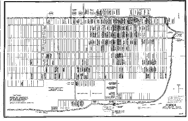
A detailed map of Norka (#49) drawn from the memory of Conrad Brill at age 90 which represents his recollection of the village up to October 1921. The map is available for purchase from the American Historical Society of Germans from Russia (AHSGR).

1922 Map of the Volga German Commune

1926 Map of the Administrative regions of the Volga German Autonomous Republic.

1934 map of Norka
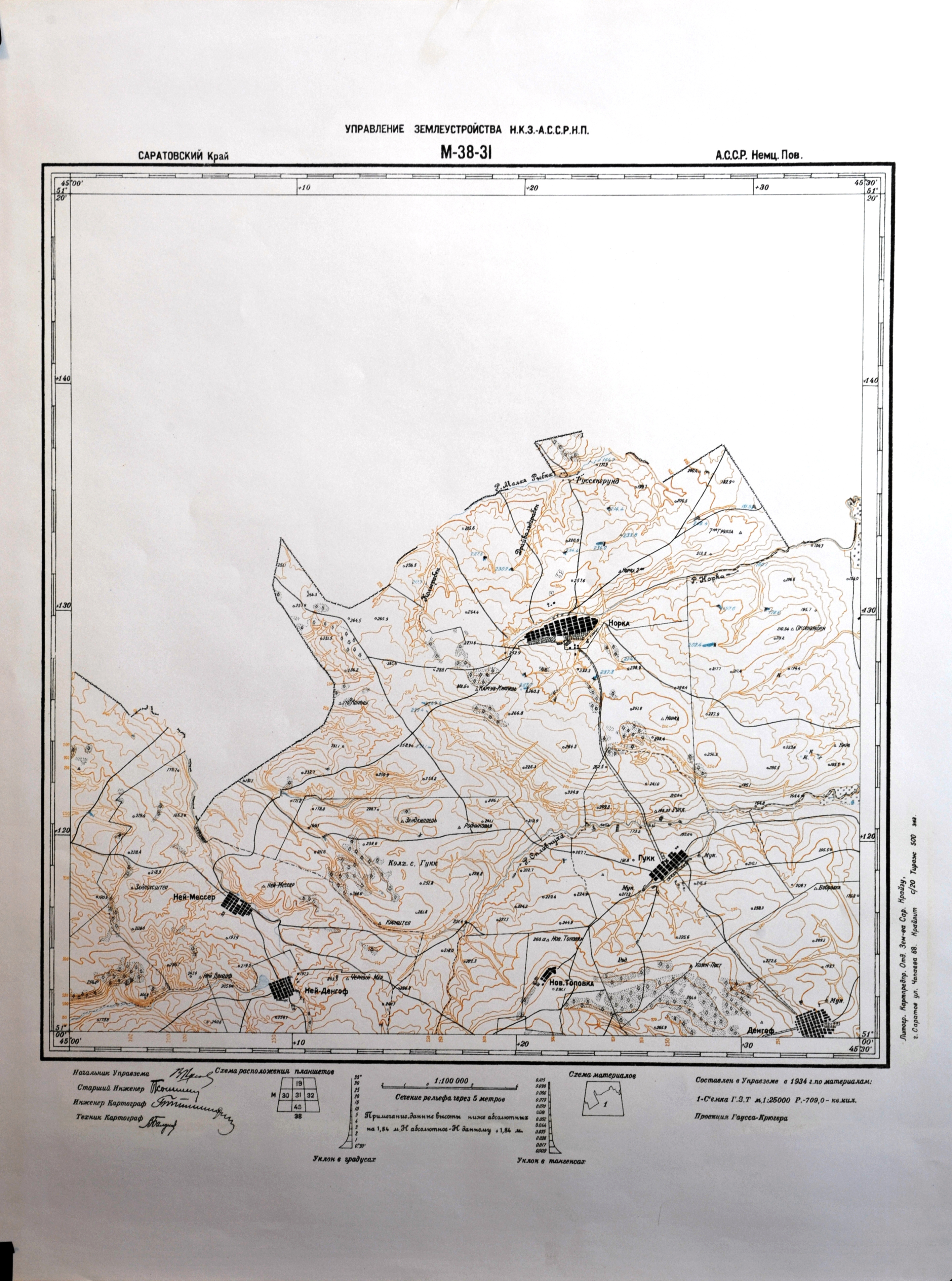
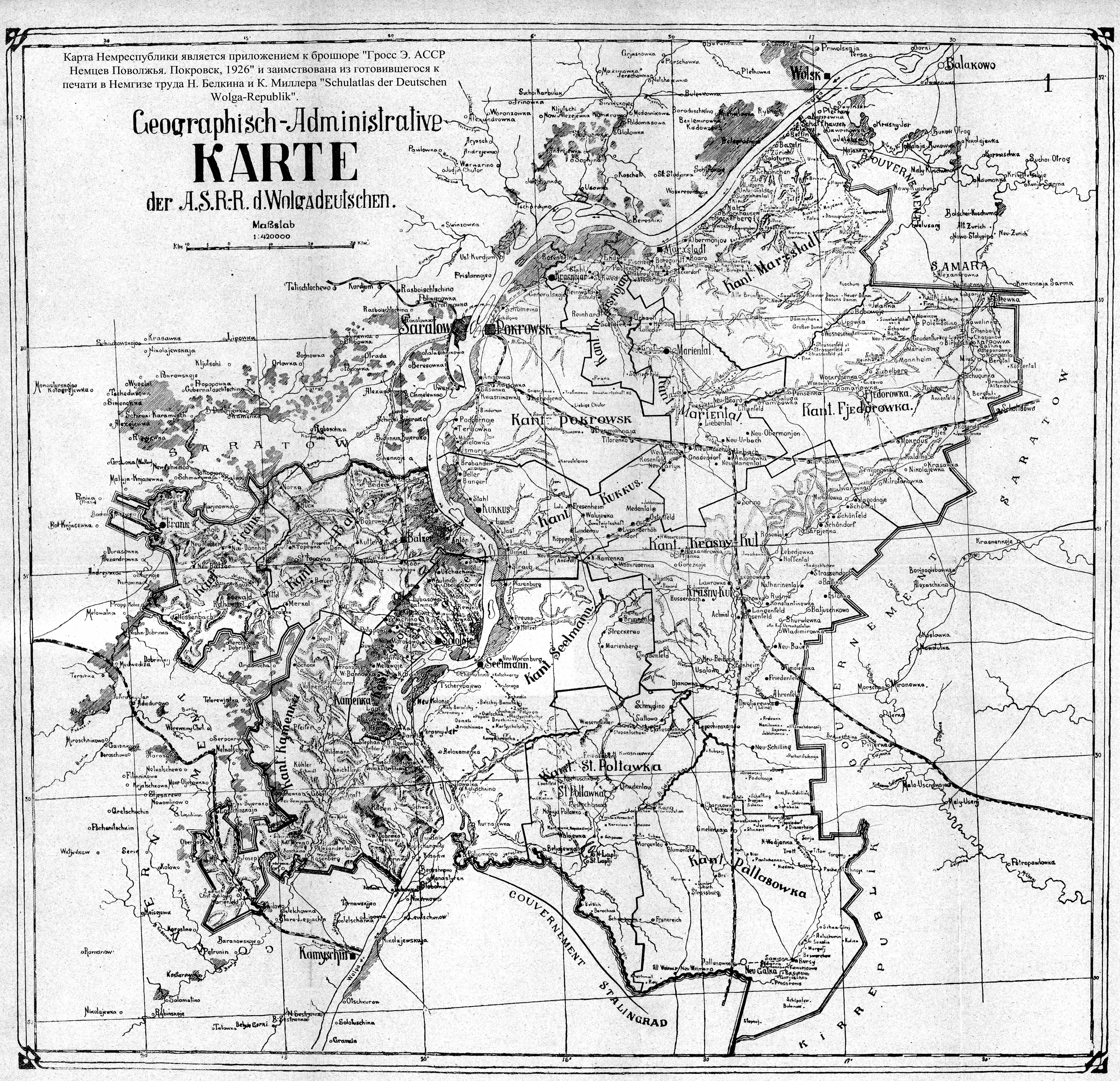
1934 Soviet map of the Autonomous Volga German Republic. This section of the map shows Norka (Hopka) and the surrounding villages of Neu-Messer, Neu-Dönhof, Huck and Dönhof. Click to view a larger image.
1934 Norka map
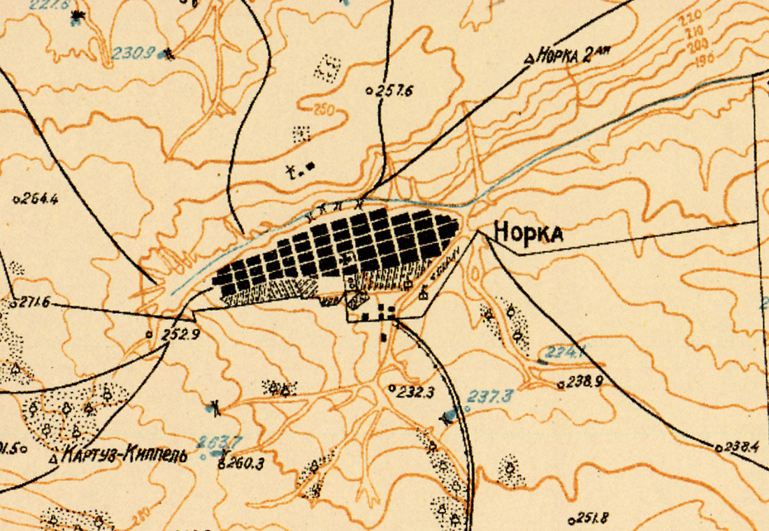
Section of 1934 contour map (see above) depicting Norka and the surrounding area including the street layout, church location and other geographic features.

Picture
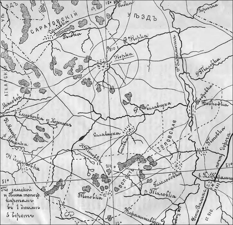
Map from the Russian encyclopedia titled, "Historic and Geographic Dictionary of the Saratov District," compiled by A. N. Minkh, a member of the Saratov Scientific Archive Commission, and published in Saratov in 1898. Norka (Russian = Hopka) is circled.

Picture
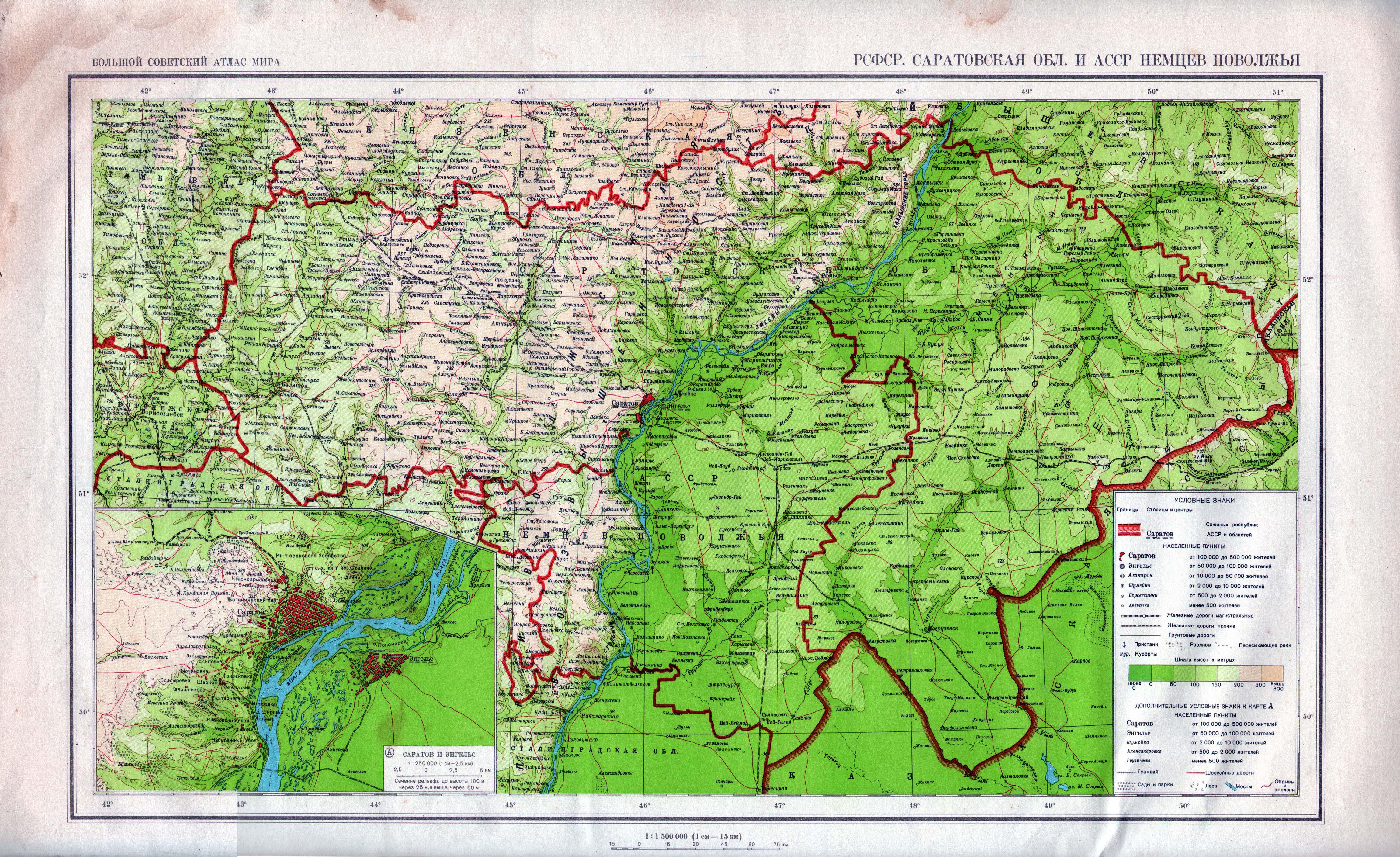
Map of Saratov Province from the Soviet era.

Picture
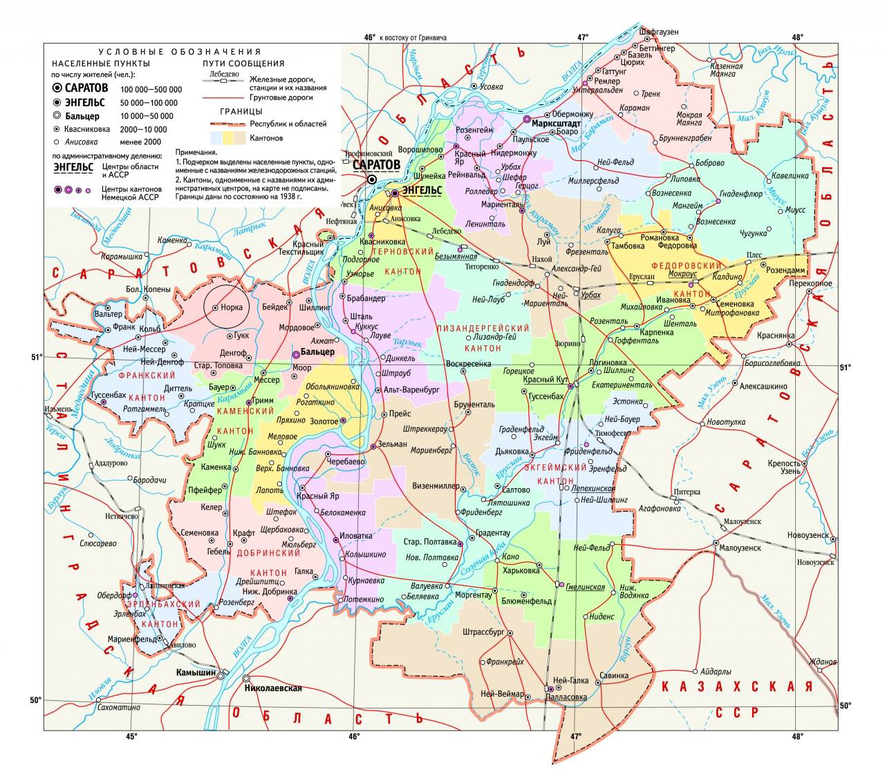
Map of the Autonomous Soviet Socialist Republic of the Volga Germans in 1935. Norka is circled in red. A proposed railroad is shown on this map running from Saratov to Millerovo. Due to the outbreak of WWII the rail line was not completed.

Geographic Map of the Volga German Autonomous Republic

1936 Norka map
This 1936 map of Norka (Russian spelling = Hopka) was obtained by Alexander Schreiber of Moscow, Russia. According to native Norkan, Konrad Urbach, until the late 1930's there were no street names in Norka. All streets were numbered (such as street number 6, street number 7 and so on). On the plan above, the street numbers are visible as well as the number of houses on each (for example: N7=201). This map also shows the street names given in the Soviet era. Please note that North is at the bottom of this map, not the top.

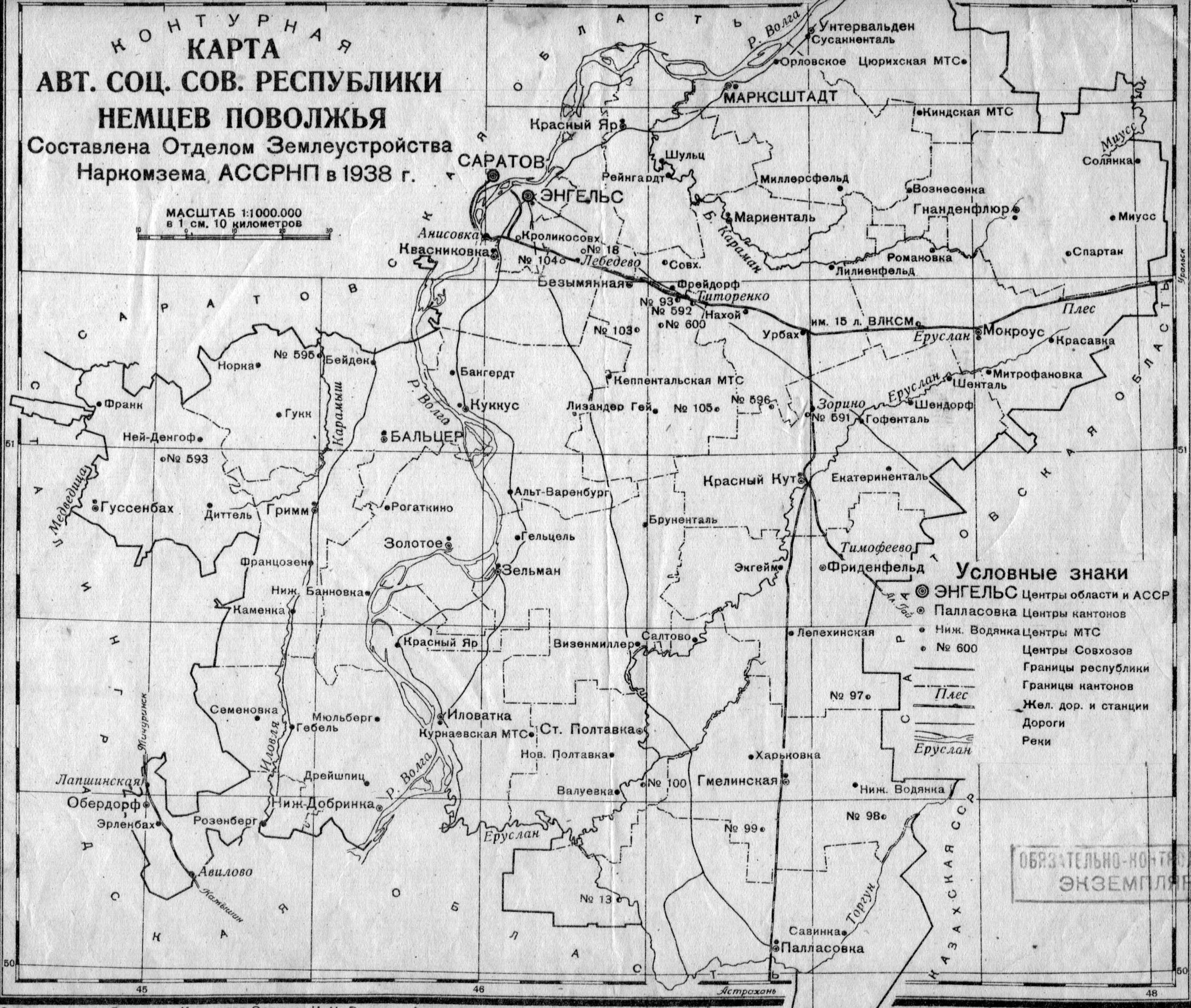
Map of the Autonomous Soviet Socialist Republic of the Volga Germans in 1938.

Map of the Autonomous Soviet Socialist Republic of the Volga Germans from 1935 o 1941.
Map of the Autonomous Soviet Socialist Republic of the Volga Germans from 1935 to 1941. Source unknown. Norka is circled by a black line.

Picture
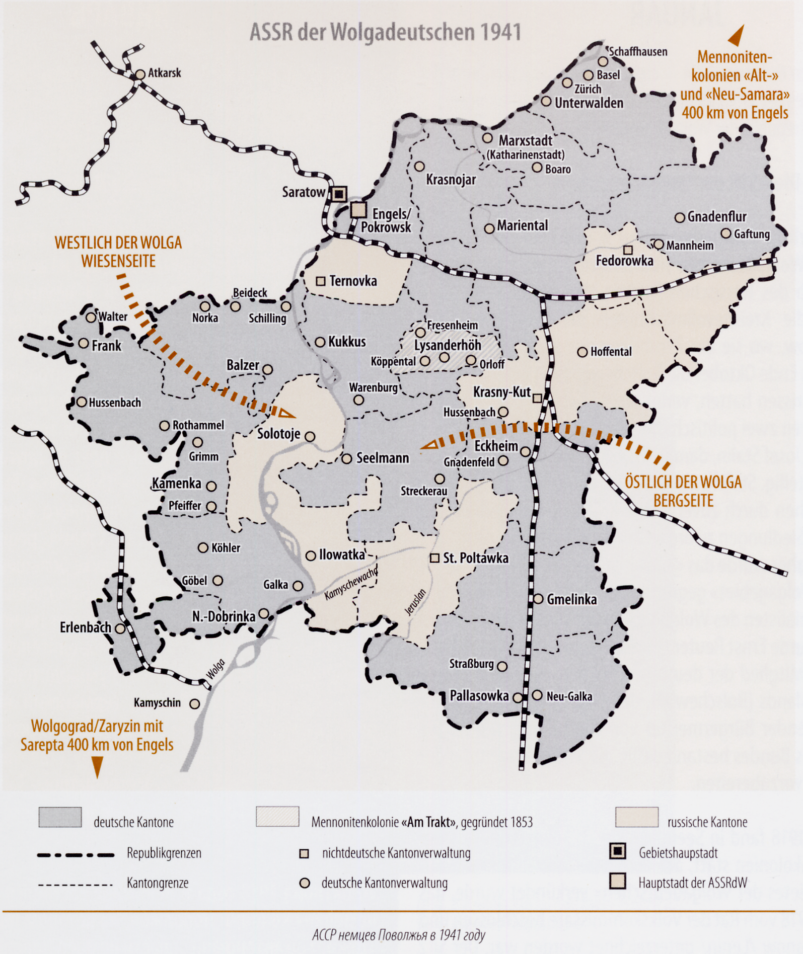
Map of the Volga German ASSR in 1941

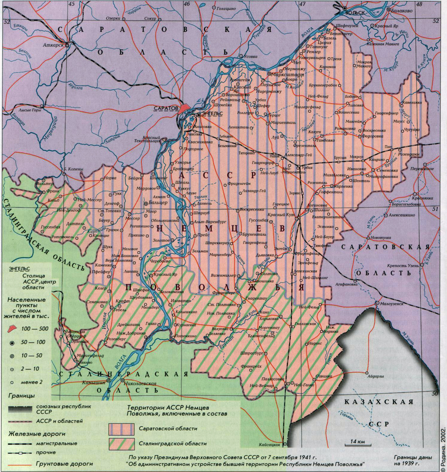
Map of the territory of the former Autonomous Soviet Socialist Republic of the Volga Germans after its liquidation in September 1941. The republic was split between the Saratov and Stalingradskoy (now Volgograd) Provinces.

Picture
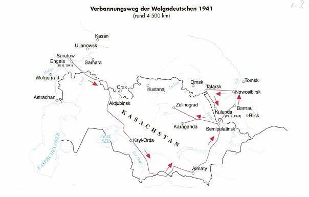
Deportation route traveled in 1941 from Saratov to Siberia and Kazakhstan. Most of those deported from Norka traveled on the southern route.

The route traveled to Kazakhstan and Siberia during the deportation of ethnic Germans from Norka in 1941.

Picture
Map showing German settlements in Europe. The Volga Germans were located the furthest to the east in the area around the cities of Saratov and Engels.

Picture

Picture
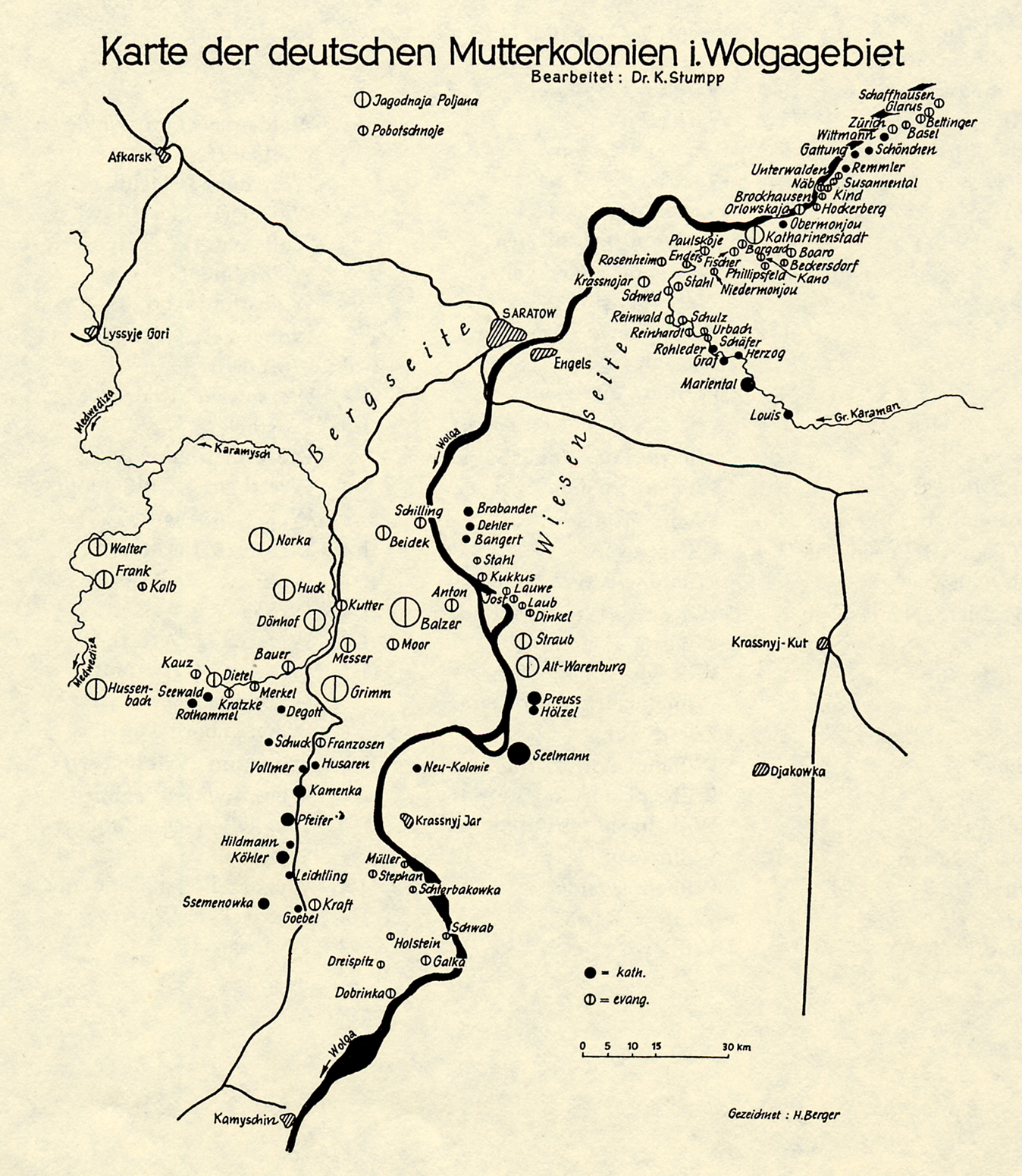
Map of the Volga German Mother Colonies by Dr. Karl Stumpp. With the exception of Balzer, Norka is the largest colony shown on this map.

Map of the Saratov region showing the location of Norka (Nekrasovo) in 2003
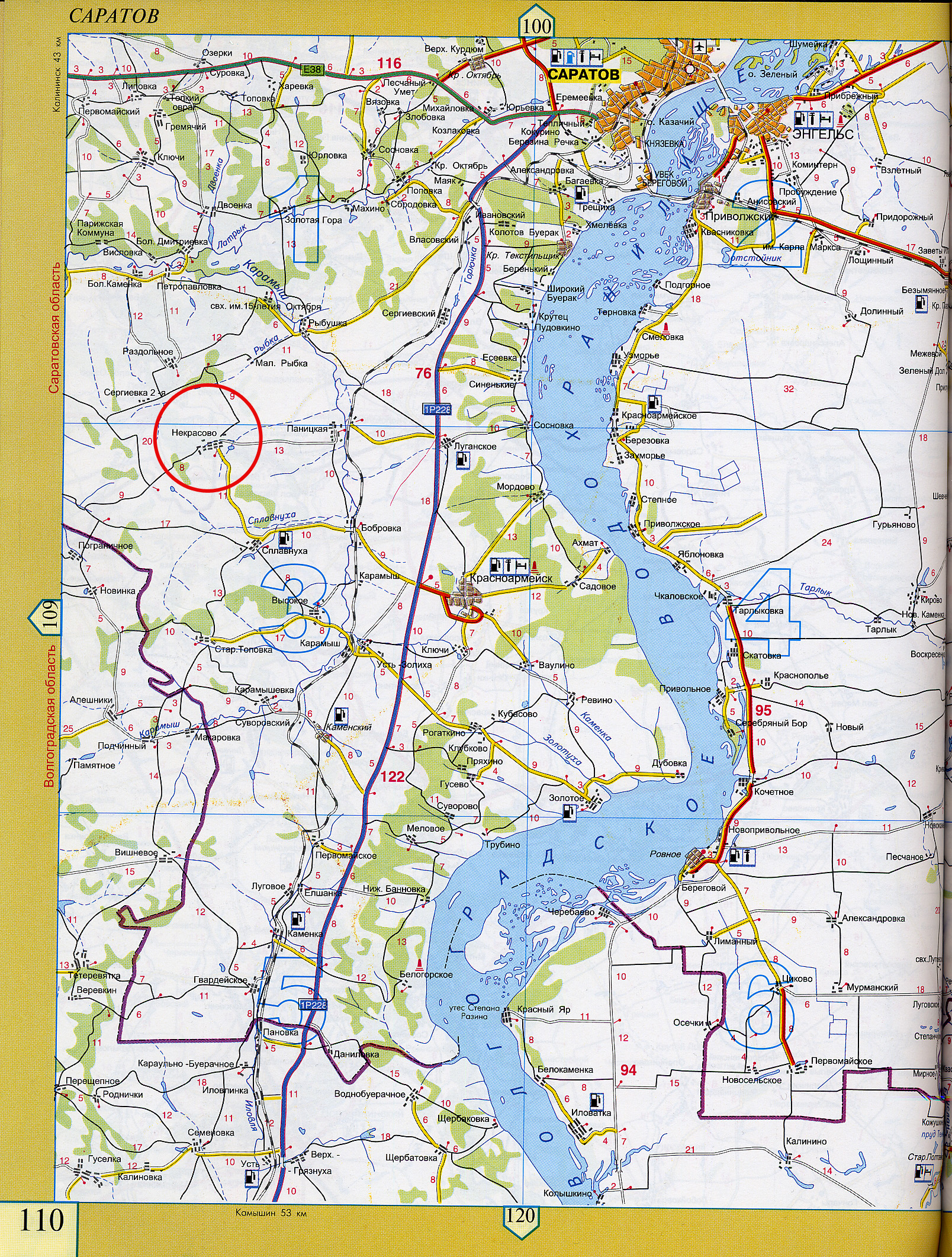
Russian road map circa 2003 showing Norka (now Nekrasovo) circled in red. The city of Saratov (Capatob) is shown to the northeast and is highlighted in yellow.

Picture
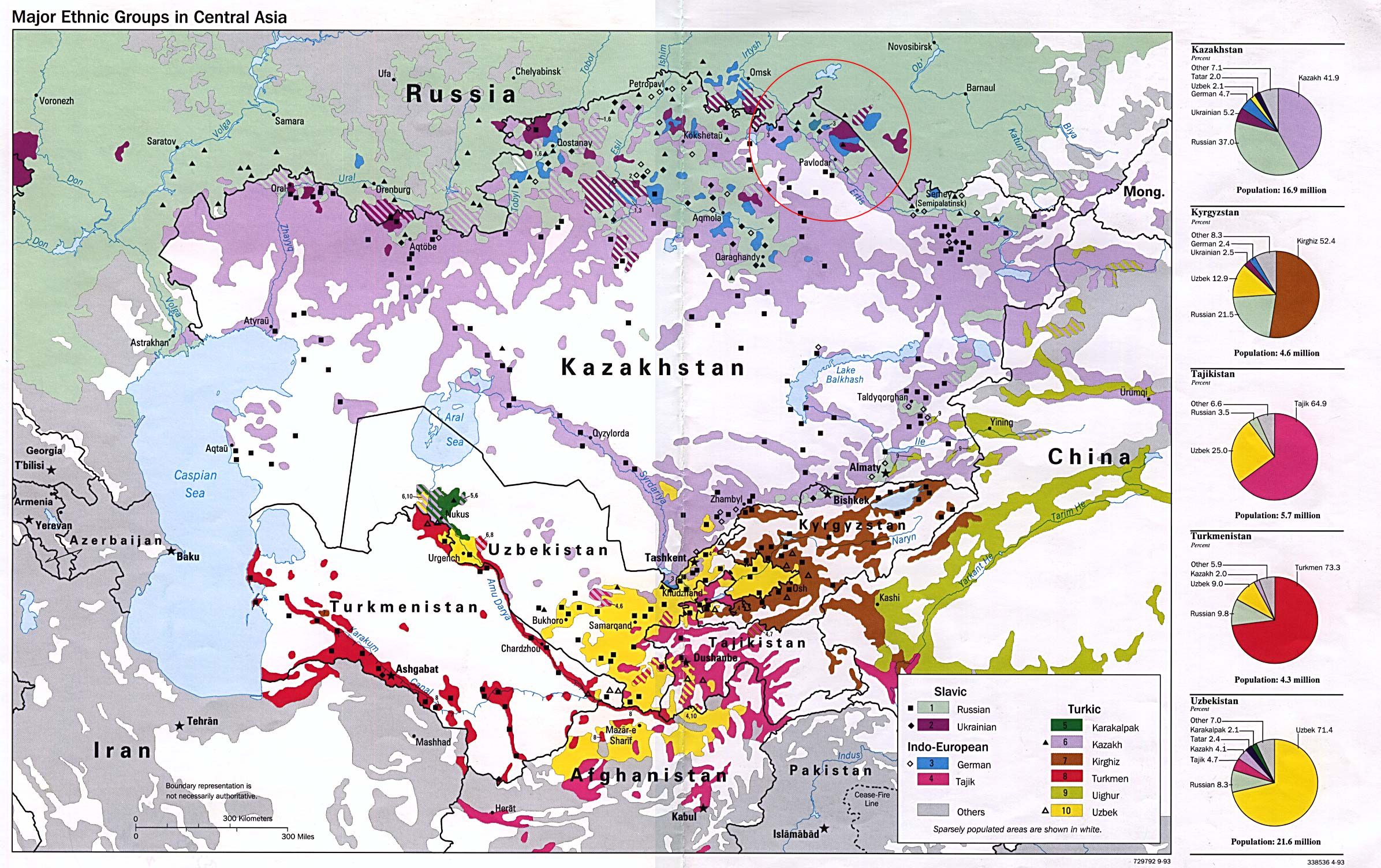
1993 map of ethnic groups in Siberia, Kazakhstan and Central Asia. German settlements are shown in blue. The area where many people from Norka were deported is circled in red.
Picture
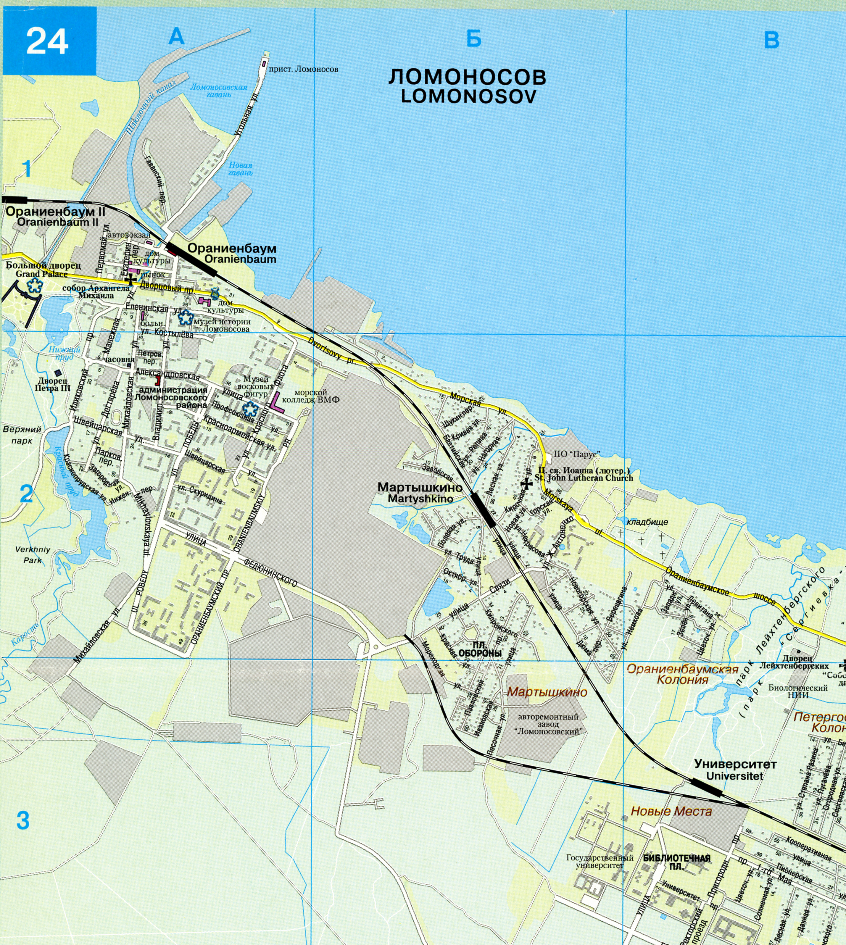
Map of Lomonosov (formerly Oranienbaum) showing the Grand Palace of Catherine II (section A-1). The canal which led from the Baltic Sea to the palace can be clearly seen although it no longer is open to the sea. The Volga German colonists arrived on the mainland through this canal after their initial landing at the island fortress of Kronstadt. Courtesy of Steve Schreiber (2006).

Map of Norka (now Nekrasovo) from the Russian website Yandex
​View a historical map of these former German counties and principalities overlaid on a modern map (courtesy of the David Rumsey Collection)
Last updated June 15, 2022.
Copyright © 2002-2023 Steven H. Schreiber
  • Home
    • About
    • Reviews
    • Contact
  • People
    • Founders
    • Personal Histories
    • Notable Norkans
    • Stories
    • Photo Identification
    • Photo Gallery
  • Community
    • Village Life
    • Entertainment
    • Agriculture
    • Climate
    • Homesites
    • Geographical Description
    • Government
    • Social Structure
    • Health
    • Education
    • A Land of Ethnic Diversity
    • Cottage Industries >
      • Sarpinka
      • Mills
    • Language
    • Population
    • Military Service
    • Crime and Punishment
  • History
    • Timeline
    • Origins of the Colonists
    • Catherine's Manifesto 1763
    • Why go to Russia?
    • Recruitment 1766
    • Planning 1764-1766
    • Marriages Prior To Emigration 1766
    • Voyage to Russia 1766 >
      • Ship Transport 1766
    • Journey 1766-1767
    • Founding of Norka 1767
    • Early Years 1767-1769
    • Norka 1769
    • Pallas Report 1773
    • Pugachev Raid 1774
    • Norka 1775
    • Norka 1798
    • Norka 1811
    • Napoleons Soldiers
    • Norka 1834
    • Daughter Colonies 1850s >
      • Neu-Norka
      • Oberdorf
      • Brunnental
      • Rosenfeld (am Jeruslan)
      • Neu Hussenbach (Gaschon)
    • Privileges Lost 1871-1874
    • Immigration 1875-1924 >
      • To the United States >
        • Colorado
        • Ft Collins Colorado
        • Globeville Colorado
        • Mason City, Iowa
        • Culbertson, Nebraska
        • Lincoln, Nebraska
        • Sutton, Nebraska
        • Burlington, Oklahoma
        • Weatherford, Oklahoma
        • Canby, Oregon
        • Portland, Oregon
      • To Canada >
        • Duffield, Alberta
        • Ponoka, Alberta
        • Spruce Grove, Alberta
        • Stony Plain, Alberta
        • Vegreville, Alberta
        • Arcola, Saskatchewan
      • To Germany
      • To South America
    • Famine 1891-1892
    • Norka 1898
    • War & Turnoil 1904-1906
    • World War 1914-1918
    • Revolution & War 1917-1922
    • Soviet Rule 1918-1941
    • Famine 1921-1924
    • Famine 1932-1933
    • The Great Terror 1936-1938
    • Deportation 1941
    • Repression 1941-1956
    • Cultural Loss 1957-2006
    • A Culture in Peril
    • Recent Times
  • Traditions
    • Food and Drink
    • Clothing
    • Holidays >
      • New Year
      • Fastnacht
      • Lent
      • Easter
      • Ascension Day
      • Pentecost
      • Founder's Day
      • Harvest Festival
      • Jahrmarkt
      • Christmas
      • Anniversaries & Birthdays
    • Crafts
    • Games
    • Folk Medicine
    • Superstitions
    • Nicknames
    • Folk Music
    • Church Music
    • Prayers
    • Baptism
    • Confirmation
    • Communion
    • Weddings
    • Funerals and Burials
  • Religion
    • Planning and History >
      • Norka Reformed Church 1767-1864
      • 1909 Norka Parish Report
    • Pastors >
      • Johann Heinrich Fuchs
      • Johann Georg Herwig
      • Johannes Baptista Cattaneo
      • Lukas Cattaneo
      • Emanuel Grunauer
      • Friedrich Börner
      • Christian Gottlieb Hegele
      • Christoph H Bonwetsch
      • Gottlieb N Bonwetsch
      • Wilhelm Staerkel
      • Woldemar Sibbul
      • David Weigum
      • Friedrich Alexander Wacker
      • Emil Pfeiffer
    • Church Practices >
      • Parochial Certificates
    • Church Buildings
    • Church Organs
    • Bell Tower
    • Brethren Movement
  • Resources
    • Family Research
    • Research Resources >
      • Arrival Records 1766
      • Descendant Charts
      • German EWZ Records
      • Soviet Gulag Records
    • Maps
    • Glossary
    • Bibliography
    • Periodicals >
      • Die Welt-Post Letters
    • Related Links